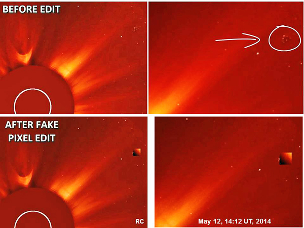
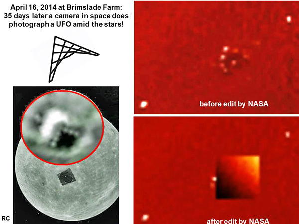
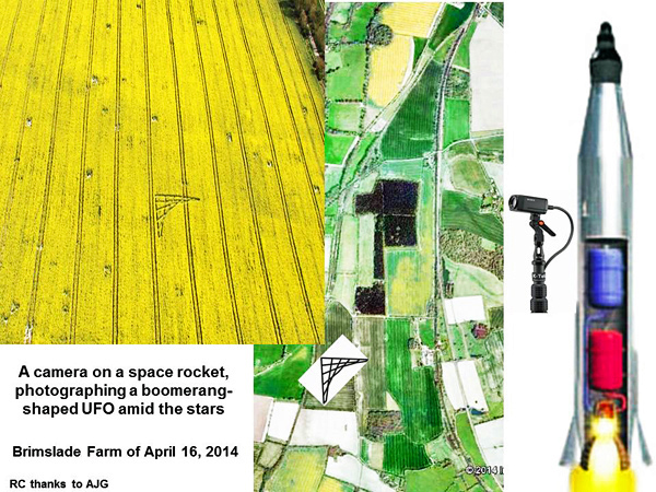
|
Echoes of missing Flight MH370:
Part 1
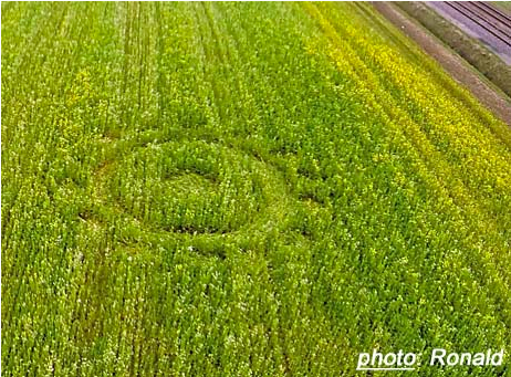
Although I
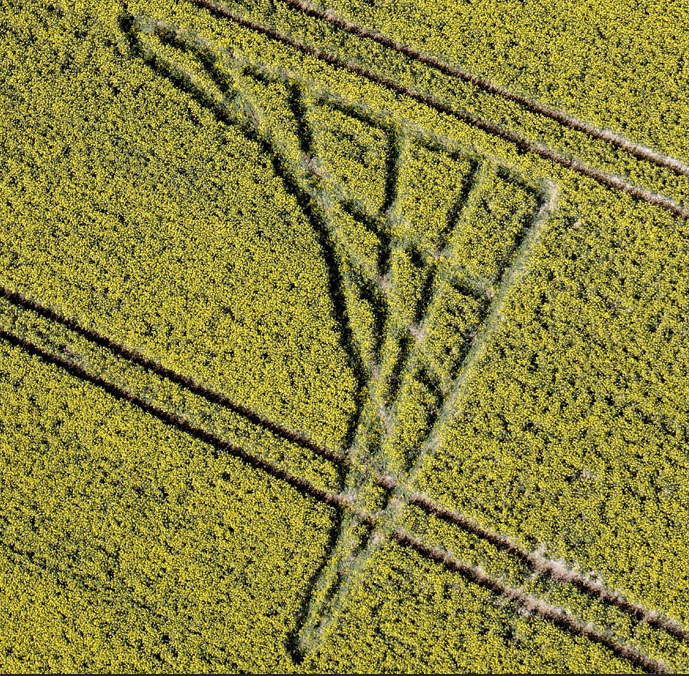
didn't survey this formation, reference to Google earth
revealed that a familiar line of latitude [ref. WGS 84] - 51.376°
N, which intersected the centre of the renowned Milk Hill circle
of August, 2001 [which I did survey] - passes through it or, grazes
past it. I then concluded that the meridian, 1.702° W, is
also at least quite close to the edifice. The point is
illustrated on the adapted Google earth image below:
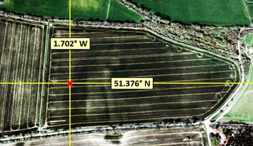
For the
purposes of this analysis I'll be using the following adaptation of
the useful drawing by Pablo Olivares, which I thank him for:
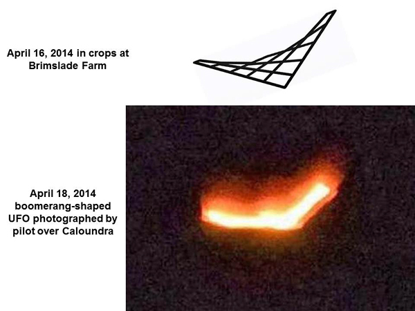
When I first
saw an aerial picture of the formation I concluded that the
structure could be a symbolic representation of some form of
aircraft. I was therefore later interested to read that Pablo had
thought likewise. I also agreed with his suggestion that there may
even be a link to the missing Flight MH370. Indeed, I soon realised
that a quantitative relationship between the crop circle and the
enduring international tragedy could actually be staring us in the
face.
However,
before pursuing that matter I'll show that the builders of this
ostensibly innocuous-looking edifice left a clear message for us,
which they were inviting us to ponder over.
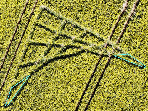
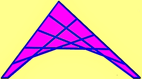
The formation
can be considered to consist of three arrowhead-like structures that
have been merged together. These figures comprise a total of 15
[= 9+5+1] enclosures, and are shown in the symbolic image
below, where the arrowheads have been separated and numbered,
1-2-3:
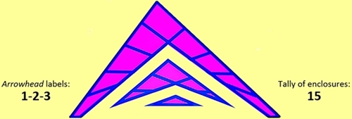
Although this
labelling of the 3 arrowheads could hardly have been simpler,
and would have been executed by many logical individuals who are
seeking to understand the structures' role, from the perspective of
prime numbers the labels used, 1, 2 & 3,
are unique, because they are the only primes1 in
existence that are consecutive integers. I concluded, then,
that the circle's adept builders may have been inviting us to
recognise another attribute of the labels, 1-2-3.
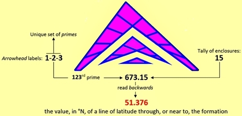
This sequence
could infer the number 123, and the 123rd
prime is 673 [or: 123p = 673], which is linked to 15,
the arrangement's quota of enclosures, in an exceedingly interesting
way.
The
juxtaposition of 673 & 15 can infer the 5-digit
decimal number, 673.15. But all analyses of crop formations
are retrospective and if we look back on this
expression we obtain, 51.376, which represents the exact WGS
84 latitude, in degrees N, of a line that cuts, or passes close to,
the formation. This subtle but simple process of generating the
51.376 is depicted below:
Having found
this impressive link between the formation and the described WGS 84
latitude, I had every expectation that the structure would
exhibit a similar intimacy with a meridian it's associated
with and I was soon satisfied that that is indeed so.
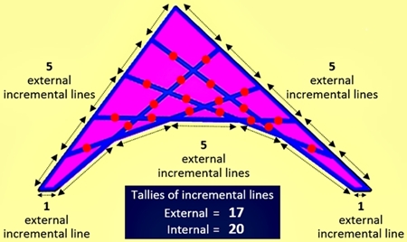
Each of the
enclosures is bounded by three or four incremental lines,
and the total allotment of these is the prime 37 i.e. 5+5
[the 2 sides] + 1+1 [the 2 bases] + 25 [= 5x5, the 5 spokes].
But these incremental lines also form two distinct groups:
17 external lines [another prime!] and 20,
internal, as illustrated below, where the latter internal
lines are marked with red dots [these help to highlight the fact
that the lines are arranged in clusters of - 1, 2,
3, 4, 4, 3, 2, 1 - numbering
8 in total, where 8 happens to be the prime rank
of 17 (i.e. the 8th prime is 17)]:
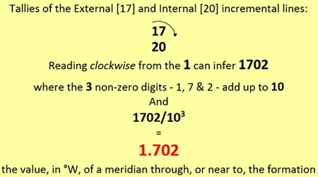
If we now read
from the above array of two numbers [i.e. with the 17 placed
above the 20], starting at the 1 and moving in a
clockwise direction, we can infer: 1702.
But the 3
non-zero digits in 1702 add up to 10,
and the expression 1702/103 yields 1.702,
which is the exact value [in ° W] of the meridian that was depicted
in Image 1.
This subtle
but simple process of generating the 1.702 is repeated in the
illustration below:
The ease with
which the foregoing bonds between the formation's structural
composition and the geographical coordinates of the point linked to
it can be identified suggests, as implied earlier, that we were
being invited to discover them. And if that is so, a question
has to be raised as to whether our attention was also being drawn to
additional coordinates of interest. Furthermore, as it was clear
that the field creation resembles some form of aircraft, I could not
dismiss the possibility that it had been intended to elucidate,
arguably, the most baffling aviation incident of the modern era: the
missing Malaysian Airways Flight MH370. And my consideration of one
key item of readily available information certainly supported this
idea.
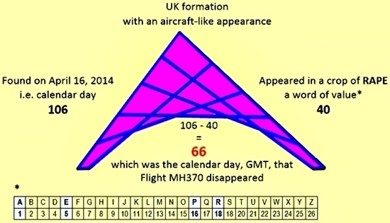
I knew that
the date of the formation's appearance in a crop of RAPE, April 16,
was the 106th day of 2014. But having identified,
over the considerable period I've been interested in them, many
circles where the crop they were found in embodies relevant data, I
was now drawn to the fact that the value of RAPE [as per the basic
cipher: A=1…Z=26] is 40 [= 18+1+16+5].
I realised
that the described 106 exceeds this 40 by, 66, which
corresponds to the day of the year [GMT] that Flight MH370 went
missing i.e. Friday, March 07, was the 66th day of
2014 [the Boeing 777 left Kuala Lumpur Airport early Saturday
morning, March 08, local time]:
Having
recognised this link between two of the formation's easily
identifiable attributes and a key feature of the MH370 enigma, its
day of occurrence, I discovered that relationships of an even more
explicit nature exist between the field edifice and a spectrum of
details concerning the aviation anomaly. These include definitive
renderings of the following data2:
-
the number of the Flight, MH370
-
the quota of passengers and crew, 239
-
the name of the type of Boeing aircraft, 777-200
-
the time of the departure [in minutes], 1001 [= 16.41
GMT]
However, as
there's currently a great level of public interest in just one
aspect of the affair, the location of the presumed wreckage, I
decided to focus here on this specific issue.
A thinly veiled latitude and longitude
We know that
it was easy to identify the formation's coordinates [or those of a
point near it]. It also wasn't hard to see how the edifice can
replicate the numbers that define the respective values [in °, as
per the WGS 84 datum]: 51.376 N 1.702 W. But if similar data
is also being provided for a point that's located on a distant part
of the globe it would have been absurd for the crop circle makers to
have expected us to find it within a complex algorithm they devised.
Logic dictates that if data pertaining to the aircraft's coordinates
was submerged, within their creation, it should be possible for
resolute individuals to find it, without too much difficulty.
With this in
mind, then, we shall now return to the formation. And as I've
already shown that a relationship between its exterior and interior
forms conveyed key information about one of the structure's
coordinates [its longitude], I propose to undertake a hypothetical
construction. I'll remove the interior grid of 20
incremental lines, and place it alongside what then remains of
the original crop circle:
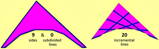
The first
point of interest is that by removing the 20 internal
incremental lines, all of which had touched the exterior, we produce
a figure with 9 sides, not one of which is subdivided.
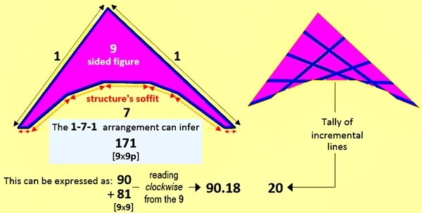
Furthermore,
the 7 sides that comprise the latter structure's
underbelly [as viewed] adjoin, on each extremity, 1 line,
and these define the edifice's 2 sides. So it's possible that our
attention is being drawn to a 1-7-1 arrangement
of lines, which can infer a numerical palindrome,
171, which has an interesting relationship with 9, the
figure's No. of sides i.e. 171 = 9 x 9p [=
19].
And knowing
that it's common in crop circles, and similar structures, for
expressions such as the described, 9 x 9p [or 3p x3p
x9p], to be used as a means of inferring, 9 x 9, which
equals, 81, I noted that the 171 can be expressed as
the summation: 90+81. I also realised that when the
larger of these numbers, 90, is placed above the 81,
it's possible, when reading clockwise from the 9, to
infer the number, 90.18, as illustrated below:
It seemed
barely credible - even to a veteran crop circle investigator such as
myself - that this elementary analysis could provide part of the
solution to a profound aviation enigma that may have already cost
the international authorities in the order of Ł100x106.
However, I could not now ignore the claims of an Australian company,
GeoResonance - regarding an alleged point [or points] they
identified in the Bay of Bengal, during a search they undertook for
the plane's wreckage - even though their statements on the subject
have not been received well by many scientists and individuals who
purport to be knowledgeable in that area of investigation.
I've been
unable to obtain confirmation from GeoResonance as to what
the accurate location of their area of interest is. However, certain
Internet sources have inevitably published clearly defined
geographical coordinates [which appear to have been leaked from the
reports that the company had communicated to the various interested
parties in confidence]. One such source, The Rakyat Post,
provides these coordinates, 20° N 90.18° E, and the
point is highlighted on the adapted Google earth map below:
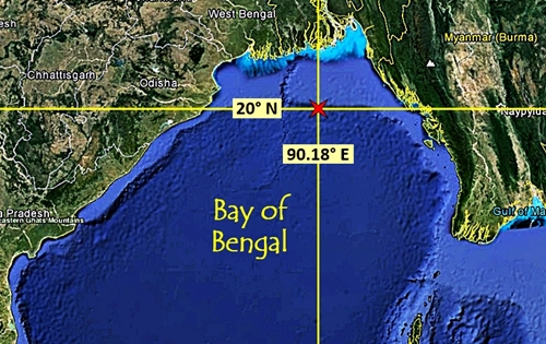
So there was a
100% correlation between the latitude & longitude that this
source quoted and two linked numbers which, as I've shown, can be
easily read from the formation: 20 & 90.18.
And as I
believed I had convincing evidence that the crop circle was alluding
to the MH370 incident and had defined, accurately, one set of
confirmed geographical coordinates, those of a point in or,
alongside it, I now reached an inevitable conclusion.
The
accomplished architects of the strange looking structure appear to
have been restating the GeoResonance case: the area in the
Bay of Bengal that has been defined should be examined with the
appropriate hardware without any further delay.
In the final
part of this presentation I'll reveal how the crop circle builders
provided us with a second tier of data about the cited aquatic
point, which is as extraordinary in its simplicity as it is
impressive in its accuracy. And I'll explain why I believe that this
additional information is conclusive.
© Neil Hudson Newman MSc [Construction Management]; May 23, 2014
Notes
1
Those of you who have read my preceding articles for the Crop
Circle Connector will know that I've long been of the opinion
that much of the numerical structure of formations can only be
understood if 1 is counted as the first prime. This discovery
did not surprise me because I've always considered 1 to be
prime, even though, when I first taught mathematics in a UK
Comprehensive School I was appalled to learn that our youngsters are
told otherwise.
The primes I
refer to in the article are highlighted in the following list [which
is headed by 1]:
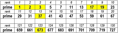
2
Although the links to the respective items of information are
important, focussing on them here would make this first presentation
longer and more difficult to read. They shall be added to the end of
the next [and final] part. I would hope, however, that certain
readers will want to look for them before then. |