|
ROUNDWAY, Nr
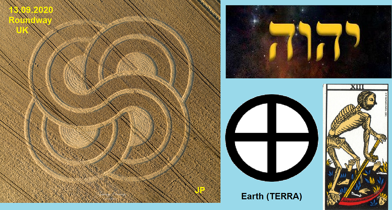
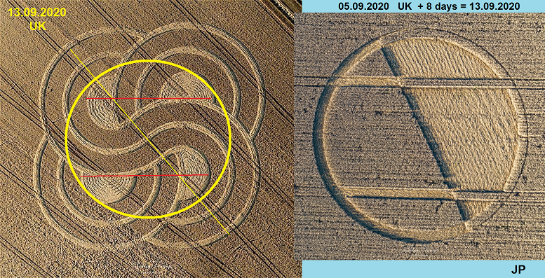
DEVIZES CROP CIRCLE (No 37) 13th SEPTEMBER 2020
WHY WAS IT CREATED WHERE IT
APPEARED? AND WHAT DOES THE DESIGN REPRESENT ?
To understand this latest late
crop formation, placed very close to the Michael Line, some aspects
of the last comment posted here in ‘Addendum to Chirton Bottom crop
circle of the 5th September’ need to be considered
In that comment it was pointed
out that the two Warminster(4) / Cley Hill(20) formations this year
had been very accurately placed to highlight about 45 and 225
degree bearings over 45 kilometres to and from the crop formation
created near Barbury Castle(9) on the 14th June this
year. This was demonstrated not by one bearing from the Barbury CC
to a circle at Warminster but by two in the Warminster area so that
the Circle Makers could show they were flagging the bisect or middle
bearing, 225 degrees. They could also show that the distance from
the Barbury crop formation to the two Warminster circles was not
quite the same but the average distance was 45km, the bearing of the
lines, about 045 degrees from True north
The comments posted about the
Patnay Bridge formation(34), 8th August, a highly
geometric design, also use the bearing, again about 045 degrees,
from the Heytesbury formation (33), 7th August -created
the day before, and distance –half of 45km, to clearly demonstrate
that many crop formations are not randomly placed on the landscape
but that each of these are a part of a design or planned layout. The
use of the same angle 45 degrees and related to distance, 45 and
half of 45km shows this is no coincidence but a design feature,
whoever the Circle Makers might be.
A look on a map shows that these bearings from the Barbury crop
circle to the Warminster / Cley Hill formations go through Devizes,
pretty well the town centre, and on its Latitude and Longitude
coordinates this Roundway crop circle was placed a very short
distance to the west of these bearing lines.
It seems pretty obvious that
the Circle Makers created this late in the year formation (37) where
they did to flag these bearings from the Barbury to the Cley Hill
/Warminster crop formations which they had carefully created, and
located, earlier in the year with great precision.
But is this an
ancient alignment being flagged by the Circle Makers this year ?
This looks very
likely...
Looking at these alignments
from Warminster /Cley Hill to Barbury Castle they pass through
central Devizes but seem to pass very close to the
Avebury stone circle complex and ‘close encounters’ by
bearing lines with important ancient sacred sites occur often in the
crop circle landscape geometry as has been demonstrated.
Avebury
is a massive ancient site, the largest stone circle site in Europe,
why was it constructed exactly in the geographical location chosen
thousands of years ago ?
Firstly, maybe because it is on
the Michael Line, if that is a very ancient general alignment. This
is a line that does not pass through the middle of the Avebury
complex but passes through the site. Glastonbury Tor and
Burrowbridge Mump have both been highlighted this year by crop
formation longitude and latitude lines and the bearing created by
the church ruins on their summits, 62.42 degrees, goes through the
Avebury circle south of the centre but within the earthwork ring.
However, if the M Line was
important, why build this amazing layout of stones and earthworks at
this particular position on the Michael Line? Was it because it
linked to another important alignment? Was that other alignment the
Warminster / Cley Hill bearings to and from Barbury Castle, being
flagged by the positions of crop formations this year?
Looking at the latitude and longitudes of these crop circle sites
the bearings to and throw between Barbury Castle and the Cley Hill /
Warminster crop formation locations pass very close, and right
through the famous Avebury circle. A ‘coincidence’ ? or is this
because Avebury is also on this second ancient alignment being
demonstrated to us this year by the Circle Makers ? If so, how long
is this Warminster / Avebury / Barbury Castle line, does it stop at
Warminster to the south and Barbury Castle to the north or go beyond
these points ?
That will take some further
research to try to establish beyond all reasonable doubt, but some
facts do already stand out and are worthy of consideration-
This Roundway crop circle (37)
is very close to this Warminster / Avebury / Barbury Castle bearings
though the Devizes area and was only created after these bearings
were being researched. Did the Circle Makers know that and add
another late crop circle to reinforce the message about this second
alignment?
The bearings pass very close to
Bratton Camp, between Devizes and Warminster, passing just to the
south of the Camp and White Horse Car Park, and a formation was
created near there last year (and in a previous year).This 2019
Bratton formation was one of the five in the 500km general alignment
of crop formations from France in 2019, a general alignment flagging
the inter-cardinal bearing of 315 degrees, this time North West.
Based on the positions of the
St Michael church ruins on the top of Burrow Mump and Glastonbury
Tor, both flagged this year by crop formation positions, (2)
and(10), Avebury is on line on what has been called the Michael
Line. That is a clear and provable FACT.
Based on the positions of the
Barbury Castle crop formation (9), Warminster crop circle (4) and
Cley Hill formation (20) the bearings between these formations pass
very close and right through the Avebury site. That is also a clear
and provable FACT (given the formation positions which seem to be
about correct from photographic evidence)
So we have two geometrically
provable bearing lines that direct us to the famous Avebury site
with very ancient origins. Are there any other geometric clues to
Avebury in the positions of any other crop formations recorded this
year ? Yes, maybe many, but here is one to consider –
There was a formation on 7th
July this year at Stanton St Bernard, (No18), Nr Alton Barnes and
just west of Alton Priors, and at 51.3642N and 1.8628W it had
almost exactly the same latitude as this last formation (37) at
Roundway – Latitude 51.3632N. If not a ‘coincidence’ were the Circle
Makers also flagging an important latitude line ? This might be the
case as East Field at Alton Priors is a well known haunt for strange
appearances in the crops it seems. East Field is at the same
latitude, just to the east of where No18 was created.
But what of the longitude of
this Stanton St Bernard crop formation this year (No18), the north /
south line...1.8628W, is that in any way significant ? This might be
the case..
The Stanton St Bernard (18) longitude going
north passes many ancient sites in this area, as so well endowed
with these, but passes close to a very significant one...
Silbury Hill,
the biggest man made mound in Europe. Is that a ‘coincidence’ ?
Why was Silbury
Hill built in that particular geographical location thousands of
years ago ?
A location that
might be being flagged by a crop circle this year ?
The longitude of crop circle
(18) at Stanton St Bernard passes just to the west of the huge
mound, going through the car park for visitors to the site, off the
old A4 road, so pretty close. But what is interesting is that the
crop circle draws our attention to this close connection based on
the longitude of the two sites as it is clear from previous evidence
that ‘close encounters’ of bearings with ancient sites can be
important
Does the
longitude of Silbury Hill (about 1.8574W at the centre) seem to be
in anyway significant ? Yes it does...
Going North along the Silbury Hill Longitude line it passes right
next to the Avebury earthwork ring on the west side and through the
site of the Avebury church positioned at that spot. Anyone
interested can quickly verify that by looking at Google Maps or an
Ordinance Survey of the area.
So, the Silbury Hill Longitude line and Avebury circle form a huge
Shen Ring as depicted in Ancient Egyptian art as a sacred symbol of
protection. Both these sites are the largest ancient examples of
their type in Europe. A coincidence ?
Given that we have two other provable alignments also going to
Avebury the chances of a third being just a ‘coincidence’ is pretty
remote. As noted in previous comments and by other researchers
‘Egyptian’ elements in circle designs are quite common particularly
the 5 pointed Egyptian star.
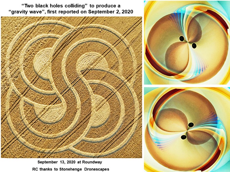
But what about the design of this Roundway
Formation No 37, could that offer some clues as to what the Circle
Makers have been doing ?
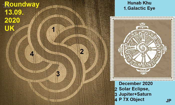
Other comments suggest the number 8, but if so
there seem to be two 8s and they are crossed
Why the number 8
The Circle Makers are clearly
using latitudes and longitudes, N S E and W, in their landscape
geometric layout of many crop formations but also the intermediate
directions for bearings, as has been well demonstrated i.e. NE -
045, SE - 135,SW - 225 and NW - 315 degrees with the cardinal
directions that divides the 360 degree compass rose into 8 x 45
degree segments, so they placed their 8 message design next to the
45/225 degree bearing lines from Warminster to Barbury Castle.
This circle divided into 8 is also reflected in
the Celtic calendar with its Quarter Days and Cross-Quarter day
division of the year into 8
We know from ancient sites in
Ireland and elsewhere that some ancient sites were aligned to
sunrise/sunsets not only at the Solstices and Equinoxes but also
half way between, just like the alignment of the pyramid causeways
at Giza in Ancient Egypt and there are plenty of Egyptian 5 pointed
stars in this years’ crop of formations.
The Silbury Hill Longitude line
forming a Shen symbol with the Avebury earthwork ring might be
consider just a coincidence by some people, but they might like to
consider other sites close to that line – Marden Henge( the biggest
in Britain ), Wilford Henge ( even closer), The Hanging Stone at
Woodborough (just next to the line), Beckhampton Penning Circle and
barrows (also just next to the line) and last but not least
THE BARGE INN at Honeystreet as
the site is directly on that Silbury Hill longitude line forming the
Shen with the Avebury Ring. If you walked from the inn to lean on
the gate into the camp site you are almost within spitting distance
of that Longitude, certainly less than a stone’s throw away !
So it looks as
if the Barge Inn may have been a strangely fortuitous place to talk
about crop circles over many years...!
ADDENDUM TO
COMMENT ON ROUNDWAY CROP CIRCLE OF 13th SEPTEMBER 2020
FURTHER IMPORTANT FINDINGS ON CROP FORMATION
LOCATIONS THIS YEAR
The area of the ancient
earthworks and stone circle site of Avebury has been flagged by crop
circle formation locations, latitudes and longitudes, and
inter-cardinal bearings in past years but much more this year, 2020,
as noted in previous comments. There were two more crop circle
formations from this year, not previously mentioned in these
comments, which have also positively flagged the exact Avebury
location beyond any reasonable doubt.
Crop Circle Connector Rumours
section - BROAD HINTON (R1)21st July, Latitude, just
south of the village church, at 51.4825N, Longitude 1.8517W, 6 km
due North of the Avebury Ring central latitude. This longitude goes
through the eastern side of the Avebury stone circles/embankment and
then on south to West Kennet Long Barrow, western end, then on south
to Milk Hill and the site of the famous huge Double Triskelion crop
circle in 2001 with over 400 separate circles in 6 spirals. Many
people think this was not a man-made formation created overnight. It
was created 6 km south of the Avebury central latitude. Broad Hinton
formation this year was 6 km north of that line.
Crop Circle Connector
report(19) EASTON CLUMP, EASTON ROYAL 10th July,
Latitude 51.3366N, Longitude 1.7044W. The inter-cardinal bearing
from this formation of 315 degrees also goes to the Avebury Ring,
14.5 km to the North West, crossing the central latitude of the
Ring, 51.4286N, at 1.8517W to match and meet the exact BROAD HINTON
C C longitude at this point. A coincidence? The Avebury Ring central
latitude of 51.4286N is being flagged by the Circle Makers with
great accuracy, it seems, for some reason. But why ?
There are no obviously
important sites at this flagged 51.4286N latitude, however, Silbury
Hill with its middle longitude tangential to the Avebury Ring, a
Shen sign, is south of Avebury at 51.4157N and that latitude is only
a fraction south of another large but smaller mound now confirmed as
having been built at the same time as Silbury, about 2400 years BCE.
This is Merlin’s Mound at Marlborough College in the town with a
Latitude of 51.4166N and at a Longitude of 1.7371W. The two mounds
are about 8.37km apart but if they were on the same longitude, one
above the other, they would form a perfect ‘8’ sign ( see Roundway
formation at Devizes 13th September, looks like a
crossed ‘8’ design)
The Circle Makers have clearly,
and repeatedly, flagged the Avebury site and its central latitude of
51.4286N this year, with great precision, something they never seem
to have done in recent years, never spot on or so obviously. If
Silbury Hill and Merlin’s Mound were set out to demonstrate nearly
identical latitudes and a set distance apart, ancient landscape
geometry, what is the message in the layout of these ancient sites
that the Circle Makers are apparently directing us to this year ?
What happens if we raise
Merlin’s Mound along the line of it’s meridian until its latitude
matches that of the flagged central latitude of the Avebury Ring ?
It then forms a right angle with the longitude line given to us by
the BROAD HINTON formation – 1.8517W. We then get -
Avebury middle
latitude to Broad Hinton crop circle (R1), distance.........6 km
Avebury Mid Lat
@ (R1) long,1.8517W, to Merlin’s Mound same latitude.. 8km
Broad Hinton C C
R1 to Merlin’s Mound longitude at Avebury Mid Lat.....10 km
The ‘perfect’ 3 : 4 : 5 / 6 : 8 : 10 ...etc, right angled triangle
with very ancient origins, known to Babylonians 1800 years BCE. Is
that just a coincidence ?
It looks as if Merlin’s Mound
at Marlborough College was placed, thousands of years BCE, as a
longitude marker to demonstrate a meridian 8 km east from a spot
within the Avebury Ring. It is worth noting that it does not matter
what units of measure you use the triangle formed by the three
locations will still be in a 3 : 4 : 5 ratio.
Of course, the Broad Hinton
crop circle (R1) marking the northerly apex of this triangle only
appeared this year and there do not seem to be any remains at the
particular place where it was created to indicate that this is an
ancient site. But that might not have always been the case. We know
that many ancient sites have been destroyed over the thousands of
years since they were set out and built. In this area the place was
possibly marked originally with sarsen stones within a mound which
is how Silbury Hill was constructed. If there was a landscape marker
like that built at Broad Hinton, at the time that Silbury Hill and
Merlin’s Marlborough Mound were set out, the mound could later have
been quite easily dispersed just leaving the sarsen stones to be
removed.
But the stones from the site
may well have been considered by some people locally to be special,
or even sacred, being from a site built in the dim and very distant
past. So the Masons who designed and built the much later churches
near the site may have decided to build these stones into the fabric
of the new structure. The Grade 1 listing of the Broad Hinton church
nearby states that it is partly built with sarsen stones. We know
that this church site has origins at least back to Saxon times and
the area may have been known as a special or sacred location for
many, many generations before that.
Worth noting that the Masonic
Fraternity seem very attached to the significance of the 3 : 4 : 5
triangle for some reason, Euclid’s 47th problem to them
it seems. The original operative Masons must have used this special
triangle to set out square sites and buildings so pretty useful in
construction. They could pick up any rod or staff and set out a
square angle. Many writers have suggested that the origins of the
Masonic Tradition lie in the mysteries surrounding Ancient Egypt
with suggested links between this triangle and the myths of Osiris
3, Isis 4 and Horus 5.
In comments made about the
Patney Bridge crop formation of 8th August this year(34)
it was noted that from the Bavarian Ammersee crop circle of the 26th
July (28), this year, using the inter-cardinal bearing of 135
degrees from its location in southern Germany, that bearing went to
Thebes in Ancient Egypt via some interesting locations. It has also
been noted that this year, and last year, other inter-cardinal
bearings give important alignments between crop formations and also
ancient sites as detailed before and in previous comments this and
last year.
It has also been pointed out that the famous Egyptian Giza pyramid
site was set out to the inter-cardinal 45 degree alignment to
ancient Heliopolis across the Nile with the most accurately aligned
pyramid to this angle or azimuth being the middle one of the
remaining three large pyramids at the Giza site.
This G2 Khafre pyramid by its angle of slope conforms to the 3 : 4 :
5 triangle. The other pyramids at Giza having different slope
angles. This is the triangle which would seem to have been marked
out by ancient sites from long ago in the Marlborough/ Avebury area,
and has been demonstrated by the locations of many crop formations
this year. The Broad Hinton formation giving the northerly apex of
this triangle.
It would be very interesting to
know if there is underground evidence of an ancient site near the
Broad Hinton crop formation position as this would provide a further
proof of an amazing ancient geometric layout of sites in this part
of the landscape of Wiltshire set out thousands of years ago.
It would still, however, leave unanswered the perplexing question of
who created the many Crop Formations that have guided us to this
geometry this year. This year of all years as we struggle with the
devastating ongoing effects of the Covid pandemic. Do the Circle
Makers know we are in big trouble with that?
The early in the
year crop formation at POTTERNE FIELD, DEVIZES on 28th
May (No 3), seems to have further geometric clues
built into its design and location. This may indicate that they do,
whoever the Circle Makers may be.
Mike Stewart
21st September 2020 &
22nd October 2020 |