|
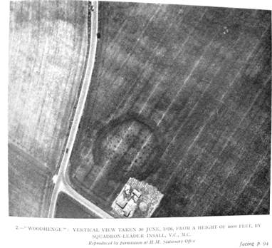
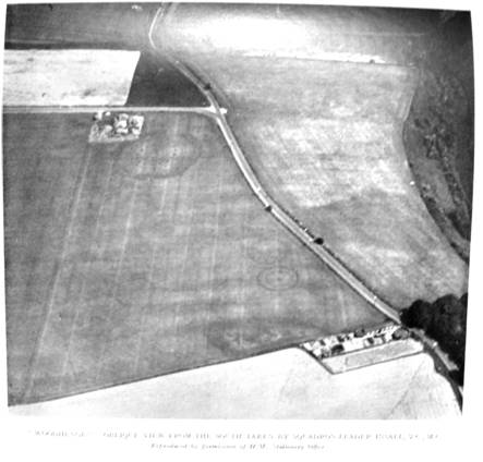
Circles of Antiquity Searching for circles in crops from the air in the southern counties is nothing new. After the European Great War of 1914-1918 the British Government sold off many working biplanes as war surplus at very cheap prices. As a result many amateurs took to the air and exploring the countryside by air became commonplace. A great beneficiary of this expansion of flying was the science of archeology. The phenomenon of Crop Marks was discovered whereby prehistoric earthworks were revealed to aerial photography by the appearance of subtle shading in fields of growing crops, subsequently found to be due to different soil densities and the presence of moisture affecting the plants directly over the outlines of the prehistoric sites, and producing ghost images, something like we often see today in the year following the appearance of a modern crop formation. Archeologists were excited by this new tool and encouraged all pilots of aircraft to look for these things and provide photographs to the learned journals for publication, some discoveries were made by serving pilots of the RAF using government planes and equipment, their photographs became copyright property of H M Stationary Office and could be reproduced only with the latter’s permission. The following examples of these discoveries are extracts from the Archeological journals of “Antiquity” for 1927 and 1933. On the 30th of June 1926 Squadron Leader Gilbert Stuart Martin Insall VC.MC took the first aerial photographs of Woodhenge near Wilton, .two of which are shown below. The whole area was covered by a tall crop of wheat and the ground was hidden at the time so the patterns are entirely due to differences in the appearance and colour of the crop. Squadron Leader Insall is credited with the discovery of this now famous rival to Stonehenge less than two miles away. See Wikipedia for more information. At the bottom right of the field there are two images of ‘Ring Barrows’ of which no traces too could be seen on the ground they having been destroyed by cultivation over centuries. Today, these barrows are not visible on a current Google Earth images. Ring Barrows are a common feature of Wiltshire archeology and many are visible and now preserved. The concentric circles of ‘Post Holes’ found at Woodhenge have recently been fitted with low concrete posts but it is thought they originally held tall oak posts used for religious ceremonies in some way. There has been a suggestion that human sacrifice may have been involved with some ring barrows because reportedly, a child’s skeleton was once found with the skull cleft in two near the center of one. Woodhenge is believed to date from 2300 BC and to predate Stonehenge. The site is well worth a visit.
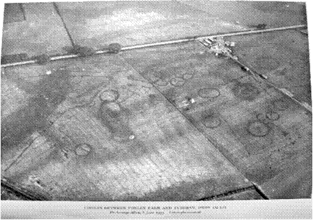
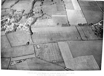
The following photos were taken by a Major George Allen probably piloting his own private aircraft, on the 6th of June 1933. The first crop field is near Eynsham, Oxfordshire and is remarkable for the large number of round barrows and other shapes revealed. The second photo is of a field south east of the first near Stanton Harcourt. Fewer clear shapes in this one but the lower right grey field holds some very indistinct rings.
Most barrows are thought to have burial pits at their centers and dark spots can be made out in some of the above images which may be such pits. What does come to mind though is that the areas where such barrows abound must have been well populated and relatively flourishing economically to have available the manpower and energy needed to create these earthworks as well as farm the land and feed their families. The circular barrows would have been marked out with the string and central peg system as used today by our hoaxers. One wonders though, where did the inspiration come from for the circular forms. Were the makers copying mysterious rings which had appeared in their pastures and crops in their days as they do now in ours, they believed to be messages from their pagan gods?. Alternatively we could suppose the possibility that the prevalence of these rings in the southern counties has been the trigger for their modern mysterious counterparts which began in the late 1980s most say. But there is good evidence of such crop circles going back centuries in England, eg. Professor Robert Plot’s ‘Natural History of Staffordshire’ published in 1676. (Google). This then eminent Oxford Chemistry Professor made an exhaustive study of the phenomenon and concluded that the cause was a force from the ‘Middle Region’, between the Earth and the Heavens, something like lightening. Jack Sullivan Feb. 2012. |