Flying
by compass readings: the new crop picture at Boskovic on June 28,
2014 and a “Viking Sun compass”
The new
crop picture which appeared near Boskovic, Czech Republic on June
28, 2014 certainly shows some kind of “compass”. When studied
closely, it seems to resemble most closely a Viking Sun
compass (see
www.ips-planetarium.org):
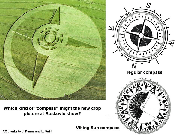
Its
“western point” is even aligned in the field slightly north of west,
where the Sun sets near Boskovic during late June (azimuth about 290o).
Fourteen
different “rectangles”, and one “open circle” of standing crop near
its centre, code for two different overlapping numbers of “360”
(degrees on a compass dial) or “365” (number of days
in a solar year):
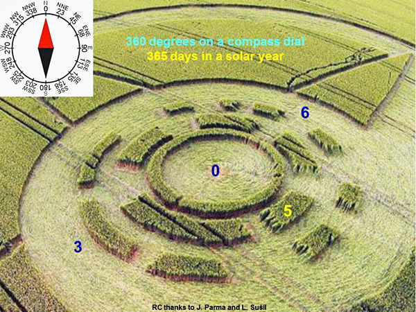
Two
groups of “rectangles” which say “3” or “6”
were drawn rotated clockwise by 20o from the “western
point” of this “compass”. Thus they also now align with where the
Sun sets in late June, along the horizon at this particular latitude
(about 20o north of west).
Some of
those “rectangles” were drawn with slightly altered length, because
they also code for another number “3.14” or “pi”. It
was specified cleverly by a partial Morse code, which reads
out-to-in along the two rings in a clockwise direction. (For a more
detailed description of this “pi” code, please see another essay
below.)
Subtle
shadings of flattened crop within the “open side” of this crop
picture suggest fast motion from lower right to upper
left, as shown in the slide below (see
www.youtube.com):
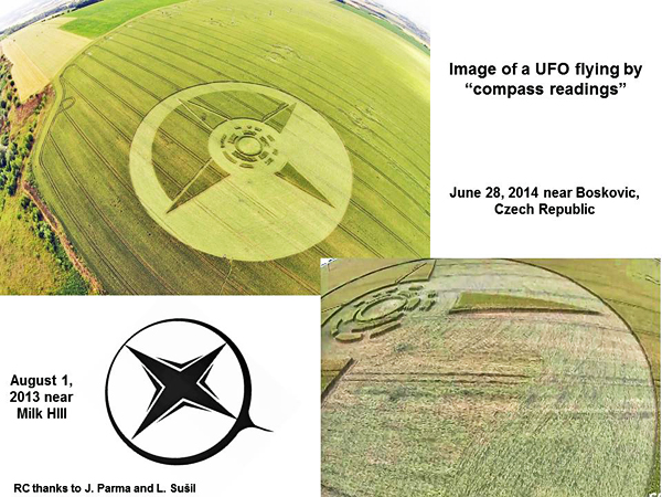
Might a
star-shaped UFO be flying soon by “compass readings and the Sun”, as
sea-faring Vikings did long ago? One can see many electrical supply
towers in the field near this crop picture, as if to suggest that
they are using electromagnetism to fly.
When we
study the broad field location of this crop picture on Google Earth,
we can see right away that it was drawn near a large “compass
needle” in the landscape:
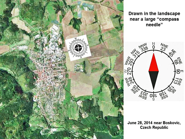
At a
more detailed level, we can see that it was drawn near some
“buildings”, plus a “man lying face down” on the left, and a “bird”
at upper right:
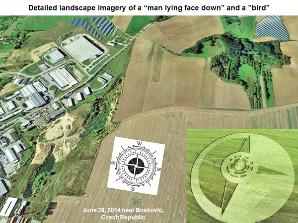
The
current interpretation of such detailed landscape features remains
speculative and poorly defined.
We
suggested in another essay below, that those symbols might be a
metaphor for “Theseas and the minotaur”, because a second reverse
Morse code in the centre seems to read “Theseas”, while its central
shape looks like a “labyrinth”. Many other labyrinth-style crop
pictures have appeared across England and Europe during June of
2014.
In any
case, we seem to understand now the basic artistic metaphor of this
Boskovic crop picture, which is that of a “Viking Sun compass” used
to help a flying UFO or airplane “navigate”. Why the crop artist
chose to show this particular field image on June 28 in the Czech
Republic, nobody (yet) knows.
Red
Collie
(Dr. Horace R. Drew)
Appendix 1. Two partial Morse codes were found near the centre
of a “Viking Sun compass”, which was drawn in crops near
Boskovic, Czech Republic on the night of June 27, 2014
The
centre of this crop picture contains 14 “rectangles” of standing
crop along two “rings”. Those “rectangles” specify primarily two
numbers of “360” (in degrees) or “365”
(in days) as noted above. Quite remarkably, the centre of this
crop picture also contains two other lucid codes in Morse,
thereby bringing the total to four!
First by reading clockwise from out-to-in, we can find a partial
Morse code for the number “3.14” or “pi”:
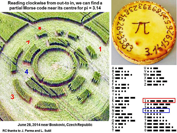
This
code seems appropriate for any field image which contains
“circular” shapes.
Next
by reading in reverse, anticlockwise from in-to-out, we can find
another Morse code for “6-27”, which matches the
night of June 27 when this crop picture appeared:
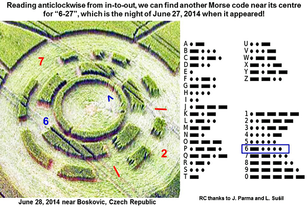
In
summary, the central region of that Boskovic crop picture
contains four different overlapping codes, all of
which make perfect sense in terms of its metaphorical content
and date of appearance. There is no indication at present that
it was made by local humans here on Earth. Its high (or even
formidable) intellectual content would seem to suggest
otherwise.
P.S. The
new crop picture in Boskovic does not appear to be a “NATO star”, or
a “star of Sumeria”. Nor does it seem to send us a “message of
distress”, as others have suggested recently with good intent.
Appendix 2. The landscape near a new crop picture at Boskovic on
June 28, 2014 shows two different “arrows”, one small and
another large, to suggest where that “compass UFO” might be
headed!
We
were unable to understand the full meaning of landscape imagery
near that Boskovic crop picture, just by studying aerial
photographs from Google Earth. Fortunately an excellent drone
video was posted which shows everything clearly (see
www.youtube.com).
The
crop picture was drawn adjacent and parallel to a “small arrow”
in the landscape, which is formed by a nearby pond:
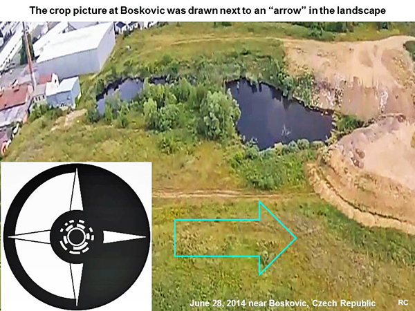
That
“compass UFO” seems to be headed locally toward some nearby
buildings, while a large “bird” watches at upper right:
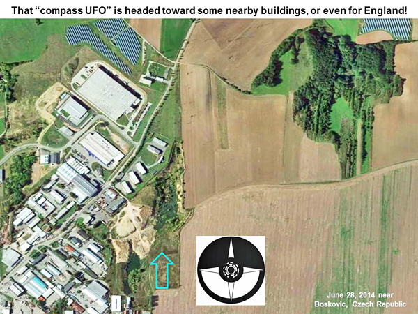
Six
different pairs of telephone poles run from bottom to top, just
below the image of that “bird” in the slide above. They give the
impression of a two-legged bird “hopping” (please see the drone
video for close-up views).
When
we study the landscape near this crop picture on a much broader
scale, using Google Earth, we can see a second “large arrow”
which points in the same direction as the “small arrow” (drawn
in blue):
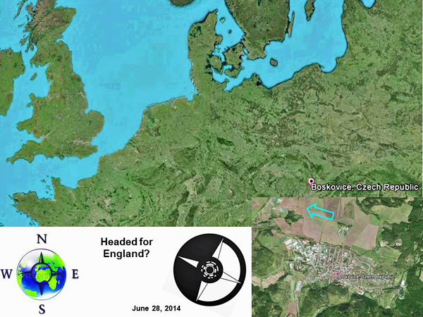
Both
“arrows” and the “compass UFO” point west-northwest towards
southern England. This is certainly an interesting insight into
the minds of those crop artists! What does the future hold?