|
|
|
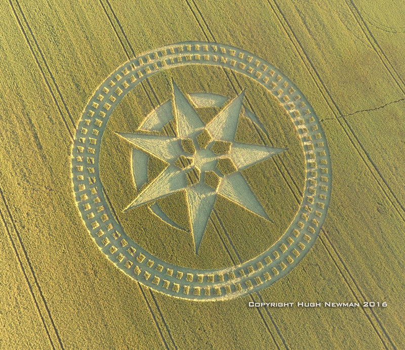
Woodway
Bridge, nr All Cannings, Wiltshire. Reported 24th August.
Map Ref: SU069623
This Page
has been accessed
Updated Friday 16th September 2016 |
|
|
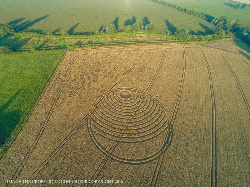
IMAGE THE CROP CIRCLE CONNECTOR COPYRIGHT 2016 |

CLICK HERE FOR THE LATEST CROP
CIRCLE CONNECTOR DVD
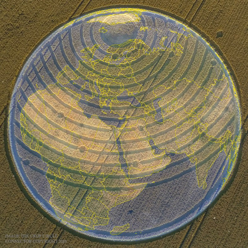
Seems this latest circle art might be referencing
points on our globe when overlaid. I have used the point closest to
the centre of the circle to align with the pyramids of Giza, assuming
the blank circle at the top of the circle art represents the arctic
circle. If we do take this crop circle as being a map reference, we
might assume the point I’ve marked green (a dissimilar shape to those
in red) is some object above the earth, and the point I’ve marked
yellow (a different shape again) as being something sub-ocean. Perhaps
the arctic is linked to all these points on land, in ocean and above
world?
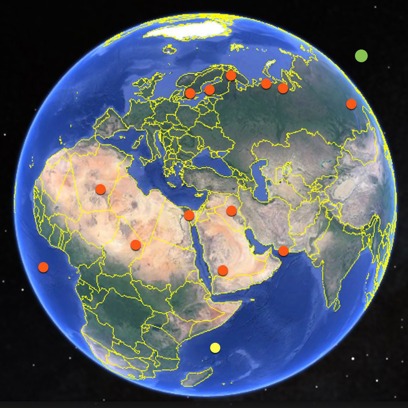
Perhaps someone else might be able to rotate the earth some other way
in order for the points to make more sense? UPDATE:-
The code at the outer edge of the circle might be
a dual code when the felled areas are read as Binary by reading left
to right from within the circle, and the standing areas read as
Morse from left to right from outside the circle. Obviously the
Morse, in this way, can be deciphered a number of ways, although
“UV’ might make the most sense if the code is considered to be
described within the outer layer of the Earth’s protective ozone.
The combined Binary (when converted to the decimal “247”) and Morse
can be read as "247 UV" or possibly "24/7 Ultraviolet”. Might this
allude to UV penetrating the Earth’s atmosphere constantly?
The shape within the space at the bottom of the
circle might considered a jagged hole, although it is difficult to
discern by looking at the pictures provided here. Precedent for this
type of shape is found in other recent circle art. Perhaps the maker
is drawing attention to a past or future event at this location near
Africa/Seychelles?
The large felled circle at the centre of the
concentric rings (at top of crop circle) appears to have internal
swirls that might be somewhat similar to recent circle art depicting
apertures. Could this literally mean an opening to something at the
north pole?
Perhaps the points (marked in red in the globe
diagram) indicate locations of past or current points of interest.
If my diagrammatic map hypothesis is correct, then all points of
interest are weighted north of the equator, whilst the “event
location” (yellow) is the sole point of interest on or south of the
equator.
Christopher Scott |

Discuss this circle on our Facebook
Crop Circles-UFO's-Ancient Mysteries-Scientific Speculations
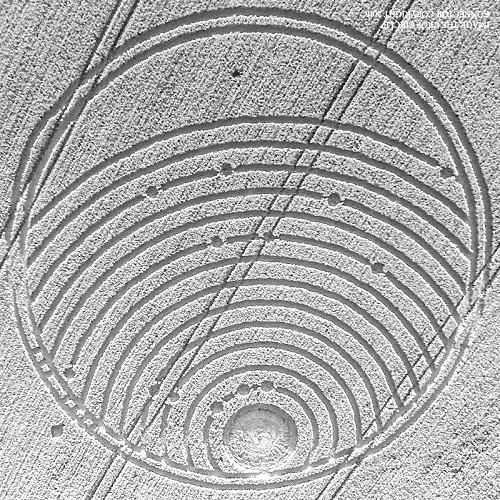
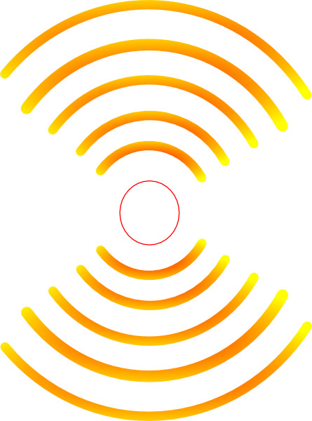
The concentric arcs are seismic waves, or
perhaps sound or water waves (tsunamis). At the top a comet
impact has caused the arcs. The small circles distributed along
the arcs and below are the impacts of minor fragments. The one
fragment outside the Earth at top right is ready to impact, or
will miss the Earth entirely. Between the two outer rings, the
seven perpendicular lines suggest earthquakes caused by the
comet and fragments. The most likely comet here is A.
Ken Heck
|
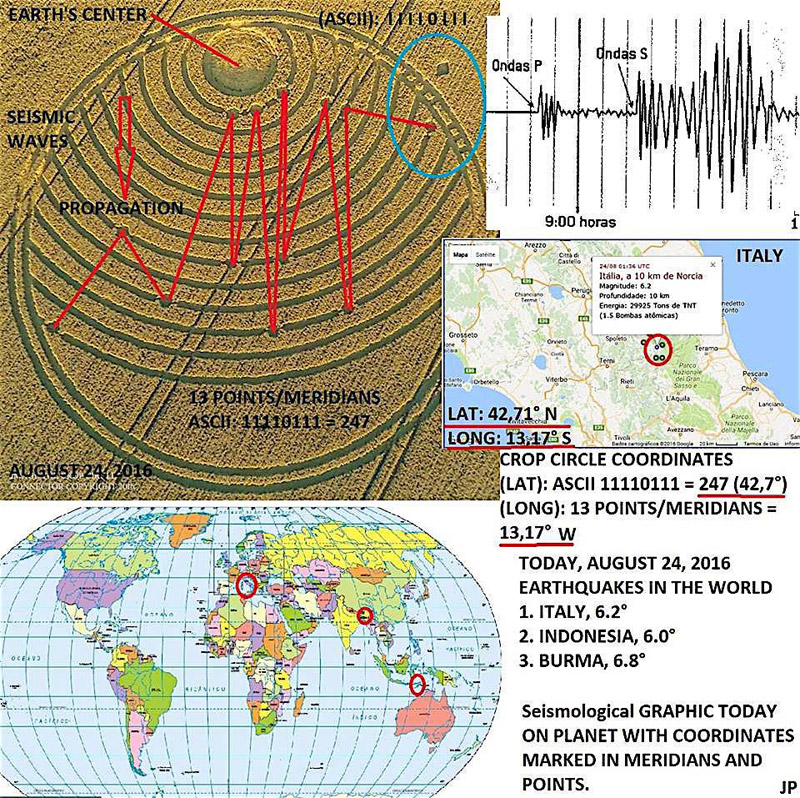
Jonas Passos posts us his latest slide that relates to the crop
circle at Woodway Bridge, near All Cannings, Wiltshire, UK. Reported
on the 24th of August, 2016, with his covering text -
'COORDINATED EARTHQUAKE
11110111 247 ASCII = (LAT: 42.7 ° N)
POINTS / Meridians = 13 (LONG: 13.17 ° W)
And 13+13 = 26 (13 points+ 13 meridians)
Inverted Number = 62
Earthquake 6.2° R (Italy)
ITALY, TODAY, AUGUST 24, 2016 6.2 ° RICHTER SCALE
AND OTHERS
EARTHQUAKES
INDONÉSIA
BURMA
New Earthquakes?' |

FOR VISITING THE CROP
CIRCLES.
 Asha
Kiran posts us her latest slide that relates to the crop circle at
Woodway Bridge, near All Cannings, Wiltshire, UK. Reported on the 24th
of August, 2016. |
Click above to join the Crop Circle Connector
Membership
| In the image of the crop circle, the
degrees of the location of the 14th dot outside the circle is approx 40
to 45 degrees. To confirm what is the degree angle we can multiple pi x
13 (number of dots/waves) = 40.85.
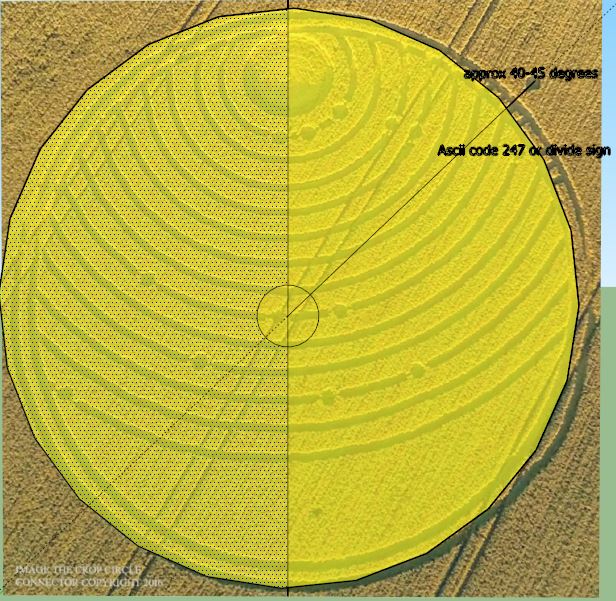
The ASCII code can only be either decimal 247 or (÷)
sign (note: key in: Alt
& type 246
on number pad = ÷)
If taken as
a divide sign, then we can take 40.85/14 (14th dot next to
÷)
= 2.917 or could be longitude 29.17 approx.
The closest point of
note to Longitude 40.85 and Latitude 29.17 is Istanbul Turkey. A current
hot spot for many reasons.
Wiz-Oz |
|
|

Cassandra Ladea
|
|
Hello dear
readers and writers,
This time I'm in totally agreement with Red Collie (Dr. Horace
R. Drew).
In his written article he described - as one possibility - that the
crop circle shows something like the star-map, or in other words the
starry night-sky, seen from Earth. That's a brilliant idea! And for
me it is a unique opportunity to work with the star-map and trying to
find something like special 'points' - stars - which correspond (or
at least come close) to the depicted dots.
Not that easy task it is…… however, I have to 'play' with the
star-map, zooming and turning as long as it will fit into the crop
circle dots - at least in approximate value!
Short note: Since several weeks and months I watch the night sky
almost every night, which of course and especially include the late
night ours! To have seen the planets Mars and Saturn in the southern
sky and short above the horizon over a longer time. And over a long
time period the planet Jupiter was been visible in the south-west
sky. But for sure since that time the view of stars has changed due
mother Earth' own movement and also influenced by the seasons, which
is grounded in Earth so called 'precession'. It is a deviation about
approx. 23.5° from the vertical centre line of Earth.
Okay, with these data I can begin to work, because the crop circle
shows three 'dots' on the first ring. Maybe these 'rings' interpret
something like our well known astronomical coordinates, with the
measurement in 'degrees', probably beginning with Earth 0° equatorial
pane / disk. But I see big differences in the used coordinate -
system: ETs use another coordinate system and it seems that in their
system the 'zero point' is just the whole planet Earth!!! So there
are concentric bands around Earth in an equally distance to each
other. But we must not mix up the rings 'distance' with the
'inclination' = angle of slope. So the only important measurement is
in degree and not a (senseless) distance. Furthermore we could or
even must 'translate' this system into our own system of degrees!
And that's a very big difference to our astronomical coordinate
system. Therefore you absolutely need to think in 'their' ways
regarding measurement and not in ours.
First I turn the crop circle upside down for to use it with star
watching programs. In those programs we stand with feet on the ground
of Earth, and the ground is beneath our feet. And we look up into the
sky: Therefore it is required to turn the image upside down.
Here I show a first image of that crop circle which I have 'prepared'
for further purpose (changed into gray scale, increased brightness
and contrast and scaled the image down):
Now I start my star
viewing program. At first I change the coordinate system into
equatorial system for better overview and for some other reasons.
Then I search for 'three dots in a line'. I remember the words from
Red Collie who stated: Our friend in a spaceship “saw” Antares,
Mars and Saturn lined up in Earth’s night sky on August 24, 2016…
Yes Red Collie, so far that's right - but unfortunately they are
not in a line when seen from Earth viewer's position and
looking south-east. For to illustrate the situation I show a
screenshot of my program:
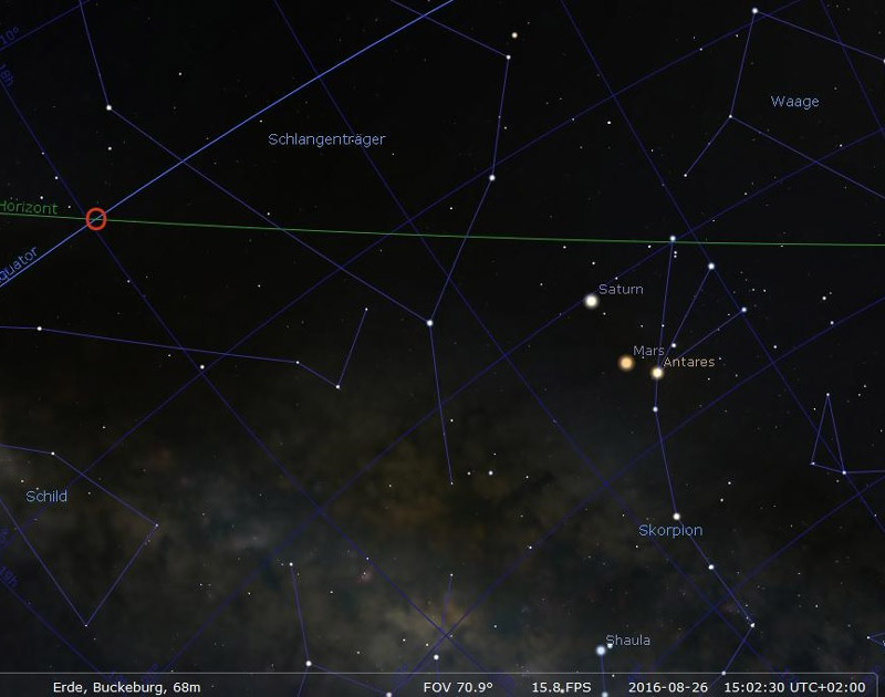
Notes: At the bottom of image you can read: 'Buckeburg' which is my
hometown here in Germany. Screenshot taken at 15:02:30 local time,
UTC + 2 hours.
Next screenshot shows the next three planets in the southern sky:
Jupiter, Venus and Mercury - but they are not in a line as
well:
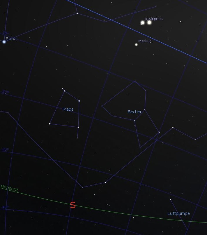
So these two
'candidates' with three planets each - are useless. But - and I
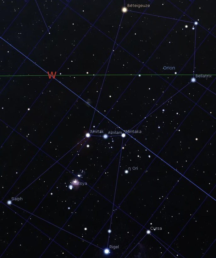
repeat - But there are three stars (and not planets) in a LINE !!!
And you know them as the famous three 'belt stars' inside the
star image ORION!!! They are named (from left to right): Alnitak,
Alnilam and Mintaka. So finally I have a base to work with!
With this basic
information in hands, my unbelievable hard and tricky work begins….
How can I achieve it to draw the 'lines' into the real sky image so
that they meet the dots on the concentric rings depicted in the crop
circle??? It is important to hold in mind that 'their' coordinate
system cannot be 'translated' on-to-one into our coordinate system,
unimportant which system we use: ecliptic, galactic, azimuth. Even
the equatorial coordinate system, which I use here in all my
screenshots, cannot be used directly as one-to-one, but in my opinion
it gives the best result - and the best view when comparing with the
special ET coordinate system. Note: The 'coordinate rings' inside my
star program are in a gap of 10° to each other. This means that the
equator line is by 0° (zero) angle of slope and the polar star is 90°
upwards from the equator.
Another problem is the graphical restriction of pixels in width and
height inside a web page, in other words: the max pixels of an image
in width and height - without downsizing the image.
Okay, after long time of searching, thinking and drawing I can
present a first 'interpretation' of connecting the crop circle dots
with the real star map - of course in best possible consideration of
their 'position' = angle of slope = inclination:
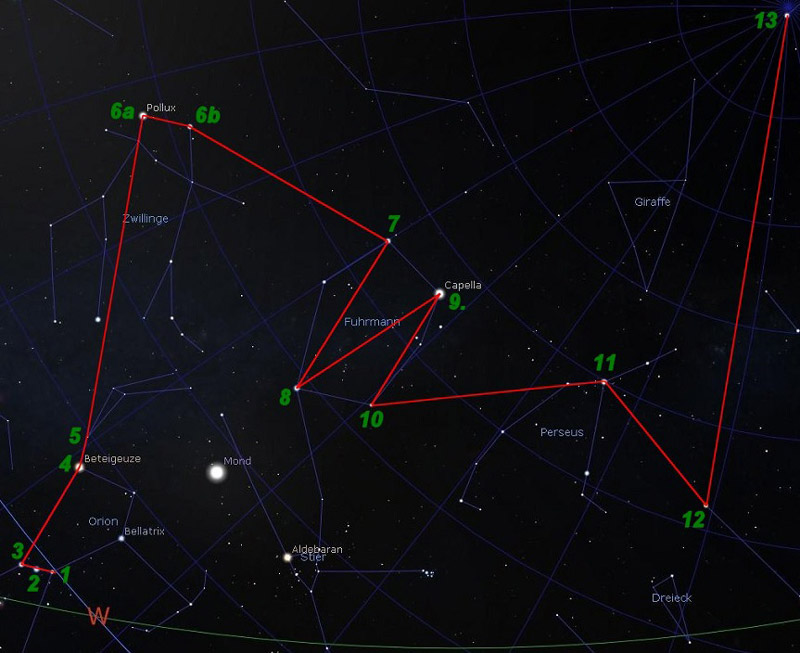
In next image I have drawn the same lines and numbers into the crop
circle image by following the dots and 'rings' :
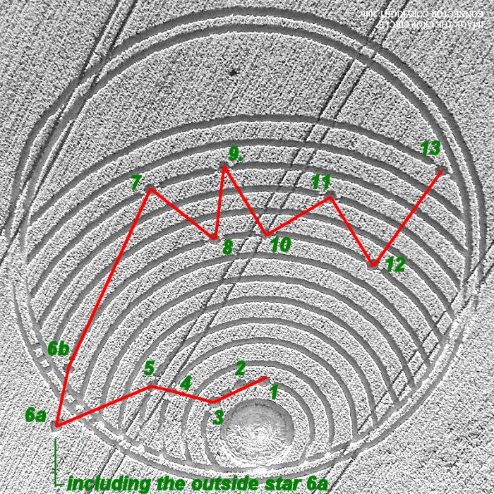
What you can see is
the same what I can see. And what do we see? Ask me an easier
question, please. Honestly spoken I have no single idea why CC-makers
have sent such a strange crop circle. As you can see I've tried my
best to present an extraterrestrial and strange image in a somewhat
reproducible 'meaning' - but sorry - I do not see the meaning. I even
don't see any rational explanation at all…….. Played the CC-makers
just around with us?
Or, maybe I have 'translated' the whole image wrong or translated it
in wrong way? And what is your opinion?
However after finishing this work after several hours I don't feel
bad at all, in contrary it inspired me to do a work like this one.
And only that makes me feel happy……
PS: I forgot to mention the star viewing program. It is the superb
program Stellarium, which you can get for FREE even in 64-bit
version! - For information and download go here:
http://stellarium.org/
Greetings from Germany

2016-08-26 - Gerd Estrup -
gestrup@alice.de |
|
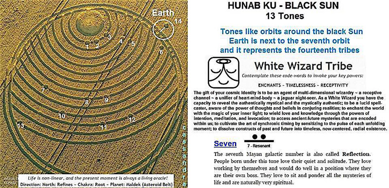
This crop circle is from the Elohim Alliances.
They use as a code the numbers seven and five - and here we have a 7
and a 14 there are 13 celestial bodies orbiting our sun as
followers of our sun in a vortex system on the date represented
here - which I do not have a celestial calendar to calculate, but
others you know do with a 14th outside the system.
Helen Parks |
|
This CC could represent a message transmitted from
the disc all over the surface of the planet. Each wave bears a coded
information represented by the dots. Thus the outer line it is the
message start and the inner the end. Somebody please decode it. This
code could be in binary 8 bits
It could be something about the end of
transmission, come back to space. May be related with the end of
this year crop circle season.
APPENDIX
This CC is a representation of the phenomena
itself. The disc is a crop circle that spreads over the surface of
the planet information in form of waves that are received in some
points by people, groups represented by the dots. Some not reached
yet.
Outside the surface a maker, a ship?, floating over the marks in
the fields
Ciaran |
|
Until the world ends up shattering
It is no coincidence that the formation arose on a day on which two
(rather) violent earthquakes took place (in Italy and in Burma). The
formation shows:
-
The earth, including 13 lines (latitudes) and dots that represent hot
spots
-
A symbol on the edge of the earth
The symbols on the edge of the formation can be considered in two
ways, namely:
-
As a binary number, value 11110111, which is the number 247
-
As Morse-code; although there are several ways of decoding, it likely
refers to (dot = short, dash = long): . . . – . . These are the
letters VI, a shortage for VICTORY. Several crop
circles in the past show
these letters (or the letter V), for example
the shooting target at Burderop Down, which appeared on July 20
this year also showed the letters VI.
To find the meaning it is also important to note that the earth shows
the latitude of 13 lines, the earth also contains 13 dots (plus a 14th
dot outside the earth at the symbols on the edge) and the number 247
= 19 × 13. The following explains the meaning of both possibilities.
The references of the number 247
There is a very convincing connection with the combined reference of
247 and 13, namely the epoch of the Hebrew calendar, which is
September 7, -3760, proleptic Gregorian calendar (October 7,
proleptic Julian). The time span from September 7, -3760 until the
date of the formation corresponds with exactly 73 × 13 × 247
“Mayan weeks” (which is 9 days instead of 7 days). The possibility
that this is just coincidence is negligible. Note that 73 days is a
fifth of a year. Hence, we can conclude that the numbers 13 and 247
refers to the creation of the epoch of the present day world 5776
years ago, which in my opinion is the start of the fall of man (thus
not to be confused with the creation of the universe and the earth).
There is a second reference, namely to the independency of Burma from
the United Kingdom, on January 4, 1948. This happened exactly
29 × 247 half weeks (25070.5 days) ago, counting from the earthquake
that happened in Burma on August 24 (about 5:05 PM local time). It
may be strange to count with half weeks, but note that we find a
reference to half weeks (3.5 days) in the Bible.
The relationship with VICTORY
The 13 symbolic hotspots on the earth have been “programmed” already
5776 years ago (or even earlier in the divine order) and relate to
the end of the present day age. They represent earthquakes and
possibly other events that are necessary to end the fall of man. At
the same time this means the victory over dark forces.
The
anthem of Burma is “Kaba
Ma Kyei”,
which means something like “until
the world ends up shattering”.
The Woodway Bridge symbolizes a crossing over.
Marc
Smulders
|
|
I refer to the comments of Mr. Red Collie, who
pointed to the same central spiral in crop circles Nettle Hill 2014
Woodway Bridge 2016. These two formations have a circular design and
both have one small point outside the formation. I believe that this
tiny dot is an important key to the solution. These are the habitats
observer. Formation left perhaps showing some explosion (supernova?)
And the right formation and the subsequent creation of black holes. I
do not want to speculate why this information was inserted into the
corn field. Maybe it has to do with research at the Large Hadron
Collider - LHC in Switzerland.
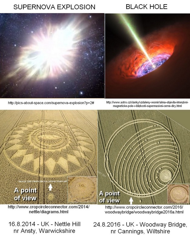
Pávková Z. |
|
Woodway
Bridge, Wiltshire
CC:
The crop
circle illustrates the location of the home star of the circle makers
in a star map. Here is an easy puzzle for its exact location:
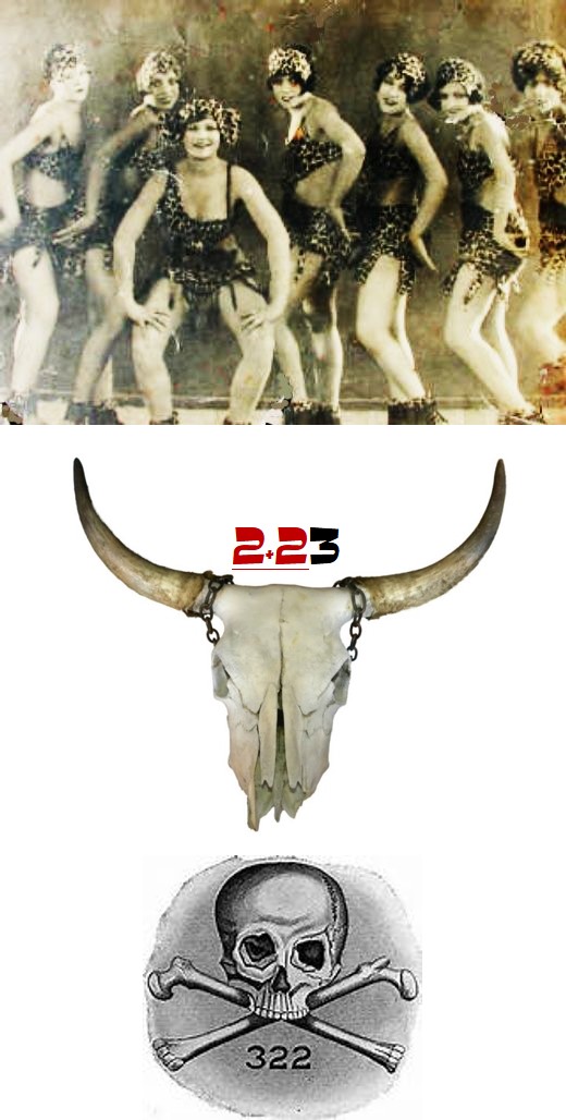
The location
of the solar system: 2+23
The CC
reported July 8th, 2016 also shows the same star and the
home planet of the circle makers when the observer is with the
dancing girls above, and hence the seven spokes.
The CC at
Stonehenge, Amesbury reported on July 8th, 2016
Illustration
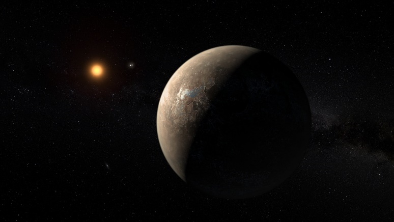
of a crescent-shaped figure in a CC does not necessarily indicate our
moon or the planet Venus, but any exoplanet passing before its star.
The following is an artistic illustration of the planet: Proxima
Centauri B, which is allegedly “recently” discovered by NASA.
The light from its star reflected by the planet, gives a crescent
shape. Thus the CC from Stonehenge shows a solar eclipse in their
planetary system.
The above
comment is also consistent with the latest CC from Brazil, reported
September 27th 2016:
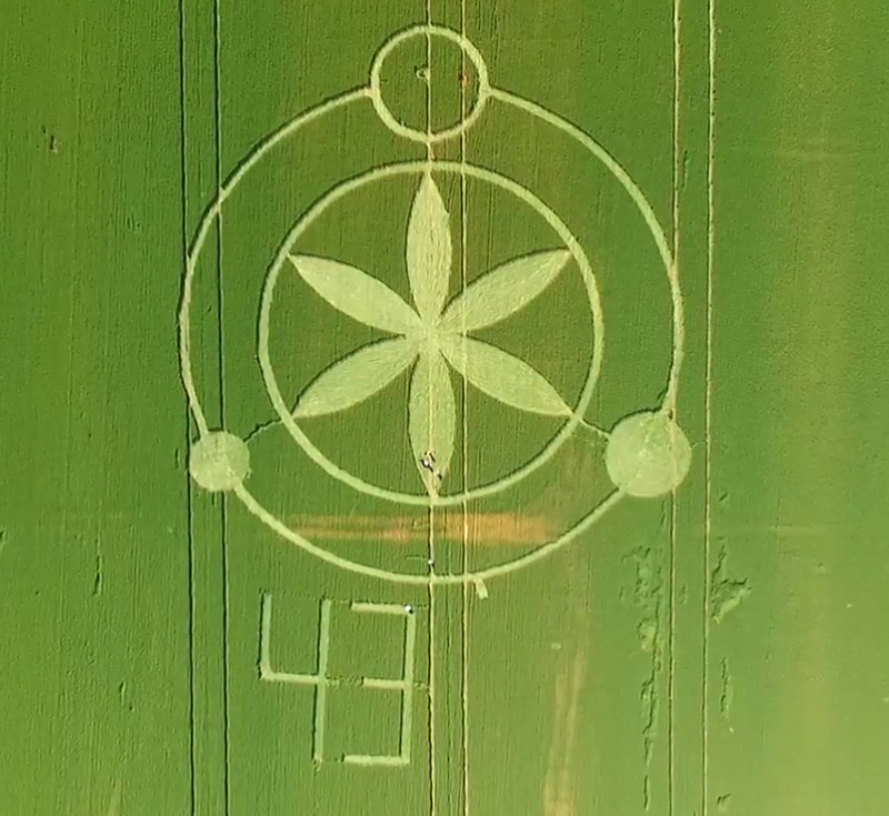
The solar
system: 2+23
which
illustrates the main sun in the form of “The Flower of Life”, a huge
planet with its moon and two separate celestial objects, which are
probably two more suns in the same orbit with the planet. In this
case, the system above depicts a ternary solar system.
The CC from
Brazil explains the location of the sun and the top orbit of the
planetary map given in CC at the Woodway Bridge, 12 more orbits of
the same system remain to be unresolved.
“The Flower
of Life” is the “Flower of Life” and the planet is the home planet of
Anunnaki, i.e., the creators of mankind. The planet may not
necessarily be the planet Nibiru, but it might be. The name Anunnaki
is superficial as they used a different name in each and every
geological location on the Earth through the ages, just to create
chaos.
The solar
system is about 283.86 light years away, only. If you are in the
neighborhood, why don’t you just pop in? :o)
To the Circle Makers:
We would
like to express our gratitude for the wonderful information that you
gave us during the crop circle season of the year 2016. The following
is a symbol of our gratefulness to you from everybody here in the CCC-community:
Berat Sancar,
updated 10.10.2016 |
|
|
BACK |

Mark Fussell & Stuart Dike |
|
 |