|
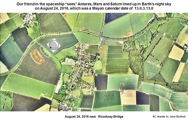
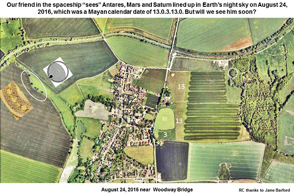
Our friend
in a spaceship was watching Antares, Mars and Saturn line up in Earth’s
night sky on August 24, 2016, which was a Mayan calendar date of
13.0.3.13.0. He can see us through the “glass windows” of his “mothership”,
but will we see him soon?
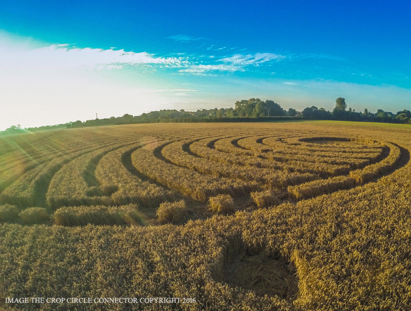
Some of the
landscape imageries near this new crop picture at Woodway Bridge are
both remarkable and instructive. We will show just a general description
of the fallen crop picture here, along with one of its most interesting
landscape imageries. Then we will discuss details of “star” or
“planetary” patterns in the fallen crop on a later date, as well as
another landscape imagery.
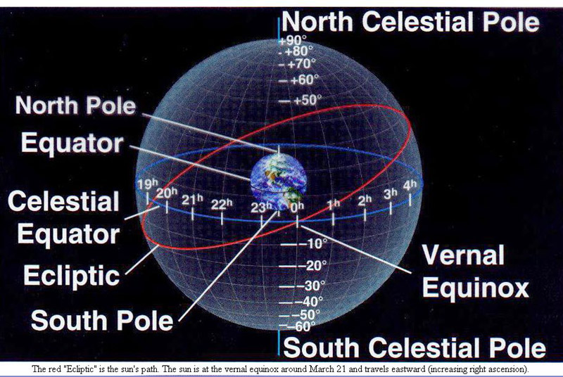
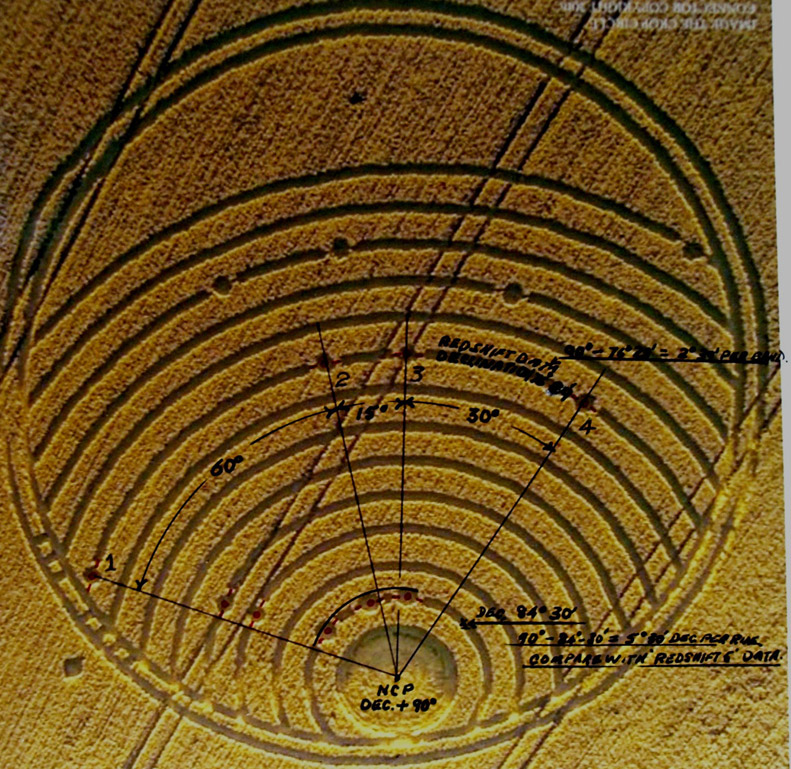
A clever
puzzle was drawn in crops near Woodway Bridge on August 24, 2016, based
on the night-sky motions of stars or planets as seen from Earth
What might
this new crop picture be trying to show us? It looks in general like a
clever “puzzle”, which has been based on night-sky motions of the stars
or planets as seen from Earth:
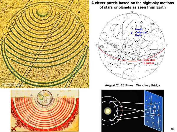
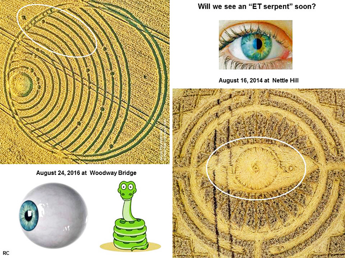
Some people
have interpreted this new crop picture as a “map of Earth as seen from
space”. Yet an equally valid interpretation might be that of the “moving
night sky” as seen from Earth, or from somewhere close to Earth in
space?
Our friend
in a spaceship “sees” Antares, Mars and Saturn lined up in Earth’s night
sky on August 24, 2016, which was a Mayan calendar date of 13.0.3.13.0
The angular
orientation of that “eye and pupil” as drawn in crops matches closely
the landscape image of an “eye” (circled in white) of a “man”, who is
“standing in a spaceship” on the right:
He is
looking down at a series of “back-and-forth loops” which number “13” on
top, or “13” below. Another symbol for “3” appears in a turkey-like
image below and slightly to the left. We mention those landscape
“numbers” here, because August 24, 2016 was a Mayan calendar date of
13.0.3.13.0 (see
www.pauahtun.org).
As for those
“back-and-forth loops”, they resemble “loops of retrograde motion” in a
Ptolemaic or Earth-centred solar system, which was the metaphor on which
this Woodway Bridge crop picture was based (please see the first slide
above). Planet Mars left its current loop of retrograde motion in
Earth’s night sky on August 24, 2016, when it passed the bright red star
Antares in Scorpio.
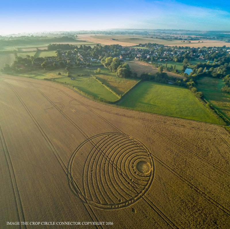
That
crop-drawn “eye” is “looking at” three large trees in the landscape on
the left (circled in white at centre left). Those three trees match
geometrically the Antares-Mars-Saturn night sky arrangement on August
24, 2016, which was drawn schematically in crops close to a “pupil” of
this “eye”.
Part of an
aerial field photograph was inset at centre left, to help illustrate how
the three-body Antares-Mars-Saturn alignment was drawn in crops. In
summary, there seems to be no doubt, in a general sense, what the crop
artist was trying to tell us!
Our friend
in a spaceship “saw” Antares, Mars and Saturn lined up in Earth’s night
sky on August 24, 2016, which was a Mayan calendar date of 13.0.3.13.0.
He can see us through the “glass windows” of his “mothership”, but will
we see him soon?
If we zoom
in on that interesting landscape image more closely, we can count
numbers of “13”, “13” or “3” more easily:
Our friend
the crop artist seems to be in a spaceship somewhere near Earth, and was
watching the Antares-Mars-Saturn sky alignment on August 24, 2016. That
particular sky alignment has been noted in crops four times this summer
(see
wessex ridgeway articles).
So what is
the fuss all about? Our crop artist friend is clearly watching the stars
or planets in Earth’s night sky. He implied on August 12 at Ansty that
he was watching Earth through the “glass windows” of his “mothership”
(see
Ansty articles). Yet will we humans on Earth see him or his
large spaceship soon? Perhaps!
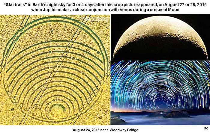
Another
important night-sky alignment soon between Jupiter and Venus on August
27-28, 2016: the Mayan dating hypothesis
There will
be another important night-sky alignment soon between Jupiter and Venus
on August 27-28, 2016 (see
venus-jupiter-nearly-touch-on-saturday). More than half of
this Woodway Bridge crop picture remains unexplained. If we flip these
same landscape images over by 180o (using Google Earth), then
we can see an entirely different set of landscape imageries, which do
suggest that we might see him soon.
Detailed
patterns within the fallen crop are very interesting, and will be
discussed at a later date. A second set of “paired dots” within this
patterned crop picture on curved arcs “3” or “4” (going away from its
“pupil’ at “0”) may refer to Jupiter and Venus as a night-sky “pair” on
Mayan calendar dates of 13.0.3.13.3 or 13.0.3.13.4, which
match August 27-28, 2016 (see
gregmaya).
That Antares-Mars-Saturn
“triplet of dots” was drawn in crops next to the “pupil 0” of this
“eye”, or along curved arc “1”, consistent with Mayan calendar dates of
3.13.0 or 3.13.1, which match August 24 or 25, 2016 when those three sky
objects were aligned.
Two other
sets of “small bars” along the outer border of this crop picture seem to
read “3” or 4”, consistent with a “Mayan dating hypothesis” for the
upcoming Jupiter-Venus conjunction on 3.13.3 or 3.13.4, or August 27 or
28, 2016 in our Western calendar.
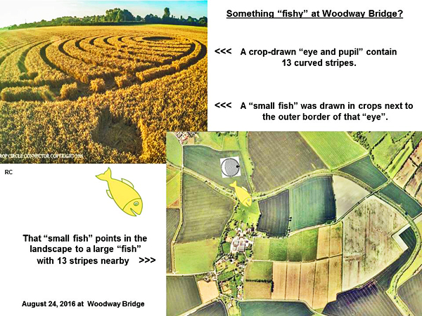
A small
“fish” shape just outside of those “small bars” points to a large
landscape “fish” just below, which has “13 stripes” in order to complete
dates of “13.3” or “13.4” for a conjunction
between Jupiter and Venus, beginning late on Saturday night August 27
and continuing into Sunday morning August 28.
This brief
analysis is therefore not intended to be a “last word” concerning the
remarkable crop picture at Woodway Bridge, but only a firm place to get
started. Meanwhile everyone should watch Jupiter and Venus form a close
pair on Saturday night! Such a rare event will not happen again until
the year 2065.
“Pay
attention to the open sky: you never know what might be coming down”
(Jackson Browne, see
www.youtube.com)
Appendix 1.
A close resemblance between the “eye opening” crop picture at Nettle
Hill on August 16, 2014, and an “eye-pupil” crop picture at Woodway
Bridge on August 24, 2016: both field images show identical central
“spirals”
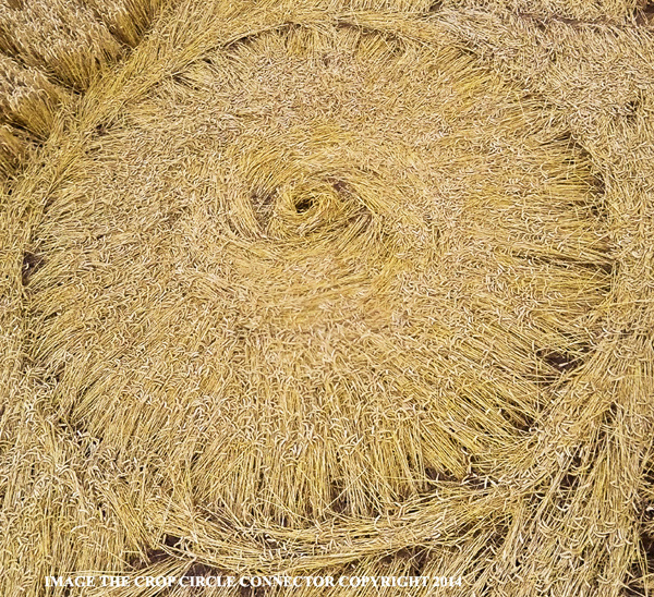
The central
spiral from Nettle Hill on August 16, 2014:
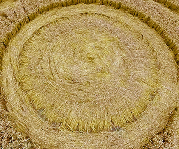
The central
spiral from Woodway Bridge on August 24, 2016:
Further
study of the Woodway Bridge crop picture confirms that its “lunar
crescent and stars” motif, drawn there in crops, matches a night-sky
date and time of August 27, 2016 at 2000 to 2200 UTC. This is exactly
when Jupiter and Venus reach their closest conjunction with one another,
elsewhere along the solar ecliptic.
Red Collie
(Dr. Horace R. Drew) |